

Session 2-1
Visualization of the Practices of the Theravadins in Mainland Southeast Asia on Google Earth
- Makiko Harada (Tokyo Metropolitan University)
- Julien Bourdon-Miyamoto (Kyoto University)
- Hidenori Watanave (Tokyo Metropolitan University)
Geo-spatial and temporal data constitute the heart of Area Informatics[1]. Beside pure research objectives, some projects require specific visualizations in order to appeal to the general public.
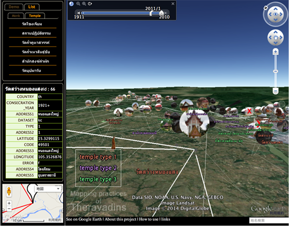
In this paper, we propose to construct visual web content with Google Earth (Fig. 1), and provide a system and interface to easily insert new data to which new information is added day by day.
In the study, we visualize the practices of the Theravadins in Mainland Southeast Asia. There are two classes of data. “Temple data” includes pictures, GPS data, years of consecration defined by the date that temple was allowed to host monks, and facilities.“Monk data” includes the id of the monks, home villages, and their whereabouts from 2001 to 2010. We extract data as expanded XML.
We describe the interface of the system below.
Operation Screen
The operation screen contains information required to control particular data on Google Earth. It contains four types of information.
- Demonstration of tracking: This shows the movement of a specific set of monks.
- List of temples / monks: When one is selected, it flies to the temple or makes a tracking line of the monk. The detailed data of the temple and the monk is inserted into the information table.
- Information table: The detailed text data is inserted here.
- Google Map: This moves in conjunction with Google Earth. It is a bird's eye view.
Interface of Google Earth
- Icon: The icon image is the picture of the temple. The icon is expanded by a mouse over. The tracking line of a monk who visits the temple is drawn, and the detailed data of the temple is inserted into the information table by a single click. Users can see the detailed high resolution pictures of the temple by a double-clicking.
- Time line: This can handle the visible information based on temporal data. It enables users to see the icon and the line within the parameters of time.
Data uploading system
We construct the PHP code which converts the expanded XML into KML for Google Earth and generates javascript automatically. To reflect them on web content, all we have to do is to add some text to “index.html”. Users input the text to call up javascript in the header, and set up an array of data to read.
This content contains a multitude of visual elements and some text data. Since the earth, which is three-dimensional, can be handled by simple mouse operation, the content is able to show research data to the general public more intuitively and easily than the previous visual content for experts in analysis[2]. Additionally, this data uploading system enables Area Informatics researchers to publish current research results easily. This content can be accessed by the following URL[3].
- Keywords
- visualization, Area Informatics, Theravadins, map
Reference
- Hara, Shoichiro: “Area Informatics: Concept and Status,” Culture and Computing, Springer Berlin Heidelberg (2010), pp. 214–228.
- http://gaia.net.cias.kyoto-u.ac.jp/mapping/
- http://temple.mapping.jp/